Remote sensing of volcanic ash at the University of Nova Gorica
The eruption of the Eyjafjallajökull volcano on the 15 April 2010 and the subsequent spreading of volcanic ash caused considerable difficulties for air traffic over Europe. The air space has reopened, however, for scientists questions still remain: the exact altitude and trajectory of the ash cloud; the distribution of ash deposited on the ground; possible long-term effects on weather and climate.
Some of these questions can be answered by the researchers at the Center for Atmospheric Research of the University of Nova Gorica who, in collaboration with the Environmental Agency of the Republic of Slovenia, monitored the spreading of the volcanic ash. The Center for Atmospheric Research is the only laboratory in Slovenia that performs remote sensing measurements of the atmosphere using laser radar -- lidar. At present, it operates two lidar devices, both developed at the University of Nova Gorica.
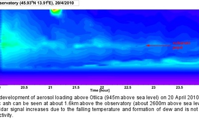
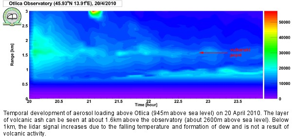
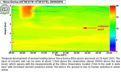
By performing consecutive measurements of laser beam scattering on the aerosol particles in the atmosphere (in this case, the volcanic ash) the researchers obtained height profiles of the relative concentration of these particles in the atmosphere and were able to monitor their transport. More scattering at a certain height indicates larger relative concentrations of aerosols at this height. Lidar measurements performed by Fei Gao, Tingyao He, professor Darko Veberic and head of the center professor Samo Stanic, revealed a layer of volcanic ash above Slovenia on 20 April 2010 at an altitude of 2600m above sea level. These measurements will help to clarify open questions regarding the transport of volcanic ash from the Eyjafjallajökull volcano and will also be extremely useful for the verification and further refinement of atmospheric models.
Contact
Andreja Leban
Public Relations
T: +386 5 3315 397
E: andreja.leban@ung.si